|
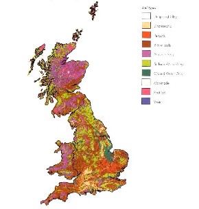
Soil MappingMany countries place great importance in mapping their soil resources, as this provides invaluable information about the types of soil present, their distribution, and formation. Soil maps are used by a wide range of individuals, including farmers, town and country planners, conservationists, foresters, and teachers to name but a few. Generally, soil maps are used to simply identify soils and their properties, but are sometimes required for more specific purposes, such as determining the suitability of a soil for particular crops, or the land drainage capabilities of an area. Like all maps, soil maps can be created in different scales – 'small scale' (showing less-detail) maps provide an overview such as shown here, whilst 'large scale' maps (showing high-detail) can be prepared where necessary. |
|||
|
|
|||
|
|
Back to 'Soils of the World' | ||