Soil erosion in Montacute village
Soil Erosion in Montacute Village
13-15 October, 2002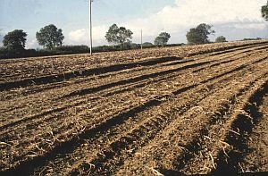
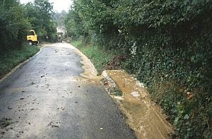
On October 13, 2002 parts of the village of Montacute, Somerset (Location: ST 495 165), were flooded when brown silty sandy soils washed into local houses. The village is not on a flood plain where flooding might be expected. The water and mud were observed to come mostly from a field above the village. But what had caused this event?
Here are the facts:
- There had been prolonged rainfall with intense bursts, especially on the evening of October 13.
- A field walk on 15 October showed that potatoes had been harvested from half of the field; the soil in this area was beaten down and furrowed with channels (rills). The rill having the greatest length for runoff was also therefore the deepest.
- The harvested area was heavily compacted by tractor wheelings. It was noticeable that the area that had not as yet been harvested showed very little evidence of surface run-off. These uncompacted soils had allowed the rain to infiltrate the ground. It was just as well that only half the crop had been harvested.
- The field sloped at an angle of 1:14 down towards a sunken lane.
- The wheelings and furrows ran approximately down the slope because the field is long and narrow - the field shape had influenced the management of the field.
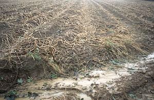
- In addition there was a belt some 10 m wide at the lower edge of the field which was compacted by farm traffic and the soil there could not absorb any more water.
- The underlying rock formation here is the Bridport Sands. This is an unusual sedimentary rock in that it is a very fine-grained silty sand (cp beach sands which are coarser as a rule). It is generally weakly structured and friable. As a result, it is very susceptible to water and wind erosion, as compared with clay or gravels.
- The Bridport Sands are a good aquifer as shown by the many springs that issue from the escarpment around Montacute and normally allow rainfall to infiltrate the surface easily. However, they can become saturated, compacted and nearly impermeable especially where they develop hardpans in the subsoil. These factors also lead to surface run-off.
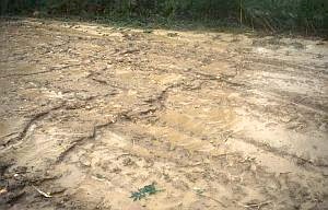
- The lower edge of the field was lined with badger setts with excavated loose sand and tunnels and these proved a focus for the cascades that poured into the sunken lane. These cascades eroded more sand from the sides of the sunken lane.
- The autumnal accumulation of leaves and sand washed off the field rapidly blocking the drains; the only way for the flood water to go was down the road towards the village!
The future
The Environment Agency regards soil erosion in Somerset as a very severe pollution problem. Drains and lower water courses are silted-up. There is also the loss of top soil, nutrients and crops. Many fields have lost up to 0.5 m of top soil.Fundamentally, the flooding and soil erosion is an economic problem. We cannot alter the rainfall pattern, the geology or the gradient of the hillslope. Ploughing across the slope might reduce erosion but would hinder cultivation. These light sandy soils will always be at risk when torrential rain strikes compacted arable surfaces. The simple answer is to put the whole area down to grass but it is not quite that simple as any farmer will tell you in the present market conditions. So what can one do with grass in order to make a living? How many dairy farms have sold up in the last few years?The farmer concerned has now relinquished the field and it has reverted to keep for horses after Someset Highways had spent a lot of money improving the drains after strong complaints from local people. The torrential periods of rain in October 2006 did not cause any problems, but who can say about the future!
Sunken lanes are an important landscape feature on the Bridport Sands; some are 20-30 m deep. They too are the result of heavy rainfall coursing down what were once unmetalled tracks pounded by wagon and animal traffic.
For further reference
Colborne, G.J.N. & Staines, S.J. 1987. Soils in Somerset 1: Sheet ST41/51 (Yeovil). Soil Survey Record No. 111. HarpendenColborne, G.J.N. & Staines, S.J. 1985. Soil erosion in south Somerset. J. Agric. Sci.,Camb, 104, 107-112.
Author: Hugh Prudden