GIS
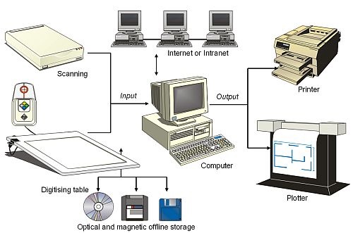
A Geographic Information System, or GIS, is an organised collection of computer hardware, software, geographic data and functionality, accessed by the GIS user capture, store, update, manipulate, analyse, and display all forms of geographically referenced information. The GIS can explore data about geographically-referenced objects and the relationships between them. GIS draws on a number of ICT tools such as database management, image processing and digital cartography. For soil scientists, using a GIS offers powerful tools for capturing, preparing, representing, structuring, managing, manipulating and presenting soils and related environmental data.
What a GIS can do
GIS offers:- easy means to work with large volumes of data - adding and updating items;
- the ability to explore the relationships between datasets. This can be based upon object's properties (like the type of soil), by location (like where woodlands are located) or by theme (like where woodlands exist with a certain type of soil). Datasets can be linked or merged to examine the geographical nature of data;
- powerful forms of output - such as maps, graphs and statistical tables - all designed to meet particular needs. GIS is increasingly used to put mapping onto the Internet too!
Examples of soil-related GIS
GIS gives soil-scientists a range of very useful tools for investigating soil properties and the relationship of soils with other types of information such as climate patterns and even where we live. Here are a few examples of how GIS are used in soil work by the National Soil Resources Institute of Cranfield University.Mapping GIS is used to create and manage the national soil maps for England and Wales. The digital maps are held in a large database, storing information about the variations of soil type across the land.
Measurement GIS is used as a tool for measuring certain qualities of the soil that vary across the land. An example is electrical conductivity of the soil ? that is something which can affect mobile phone reception in different regions.
Monitoring GIS is used to monitor how properties of the soil vary in time. A national survey of carbon levels in the soil, repeated several years later shows how these levels are decreasing over time. A worrying trend with climate change.
Modelling GIS is used to create scientific models of what happens to pesticides after they are sprayed onto fields, and whether pesticides stay in the field, or end up in rivers and underground aquifers where our drinking water comes from.
Management GIS is used to capture soil conditions across the country to allow government departments to make decisions about the best way to manage the countryside, for example by encouraging different forms of land use.
Manipulation GIS is used to explore and manipulate the relationships between different types of data, for example using a GIS to examine the location of alluvial flood plains and the locations of new housing estates can help to identify risks of flooding.
Summary
Geographical Information Systems offer a powerful tool for the integration, analysis and presentation of geographical datasets. Soil-related GIS is used for creating many types of map, for undertaking scientific work and for helping land managers to make correct decisions. GIS technology today is developing very fast and GIS tools are increasingly available, not only on PCs, but also on the Internet, mobile phones and PDA computers, often combined with other technologies such as global positioning satellite (GPS) equipment. Nowadays, GIS is an essential tool for environmental managers.